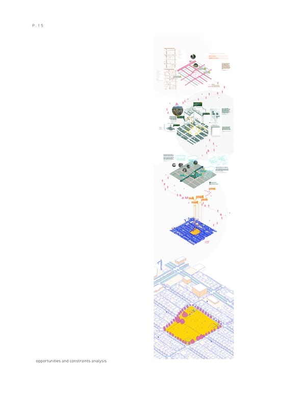
P.15 Current Transportation network T The community has identified several key features for the future Complete Street design, including wider sidewalks, plazas and gathering spaces, retention of mature trees and boulevards, and more green space. Particular attention will be paid to the experience of people using sustainable modes—providing safe, conve- nient, and comfortable facilities and routes Reduce existing traffic for people walking, cycling, and taking Future Transportation network & encourage walking ! transit. ? Source:https://guidelines.vancouver.ca/poli- cy-plan-cambie-corridor.pdf Create welcoming and defined arrivals? Potential interface with new network design ? Bike path Desired pedestrian path Road & Main Circulation create interesting views ! for residents in future ? High-rises while addressing shadows and blocked mountain view Areas off the arterials identified for high-density residential will deliver a range of affordable housing options and create a diversity of building forms. These Oak Meadows urban areas will integrate improved streetscapes to the Park connect the neighbourhood to adjacent parks, shops, W 37th Ave. and services within the Oakridge Municipal Town Center. Interact with Active Commercial at grade? Source:https://guidelines.vancouver.ca/poli- cy-plan-cambie-corridor.pdf The scope of work includes doubling Consider architecture the size of the mall to 1.4M square ! form and design for feet, adding over 2,900 residential ? units in 13 towers (market and afford- increased population able housing), the addition of 300,000 square feet of commercial office space, an 70,000 civic centre. Source: https://www.ellisdon.com/proj- ects/oakridge-redevelopment-phase-1 celebrate newcomer diversity ? A number of census variables help under- stand the diverse and complex cultural identities of people in Vancouver. The graphs below provide the top ten cultural origins reported by residents in Oakridge, a majority of residents report Chinese ances- try. Source:2020 Oakridge Social Indicators Profile - City of Vancouver Blue green systems are networks of connected park-like streets that manage water and land in a way that is inspired by nature and designed to replicate natural functions and provide ecosystem services. These systems seek to protect the ecological, hydro- logical, and social values of the urban landscape and water cycle, and to provide resilient measures to address climate change and flood management, increase connectivity, and enhance access to nature. Source: https://vancouver.ca/home-property-develop- ment/blue-green-systems.aspx The Cambie Corridor is growing, and so are the demands on its drainage and sewer systems, parks, streets, and public spaces. To provide critical drainage services, park spaces, and transporta- tion options for the neighbourhood, the Alberta Street Blue Green System and Columbia Park Renewal Project will explore innovative ! ways to make changes to Columbia Park, Alberta Street, and 43rd Address Low ? Avenue to meet our project principles. biodiversity planting Source: https://vancouver.ca/home-property-development/alber- ta-st-blue-green-system-and-columbia-park-renewal.aspxment-phase-1 Resolve current site Integrate with Drainage issue with! ? creative storm water ? Alberta street management system blue green network PERMEABLE SURFACE SEMI-PERMEABLE SURFACE Landing space for? Migratory birds Address playground ! drainage issue & update ? access water! play strategy play strategy ? ! Evaluate needs to ? update aging amenities Update and increase seatings ! ? N B A B A opportunities and constraints analysis
 Portfolio 2024 Page 15 Page 17