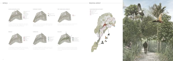
DETAILS REGIONAL IMPACT ACCESS AND CIRCULATION COMMUNITY SPACES REST AREAS AND LOOKOUTS KAIWHARAWHARA CATCHMENT Kaiwharawhara Stream Kaiwharawhara Stream Frequent Bus Routes Bus Routes Railway Railway Walking tracks Walking Tracks Play area + Community Sanctuary to Sea Walkway Sanctuary to Sea Garden Main Roads Walkway (STS) Te Mara Hupara Clearing Lookouts Site Rongoa Trail Main Roads Stream Con昀氀uence + Pipe Benches Bus Stops Exit Car parks Beginning/ End of New STS Trelissick Ciculation around the site is directed by 3 key paths. These community spaces will provide key areas that Lookouts highlight the key view over the catchment. Park Sanctuary to Sea Track, Walking tracks and a facilitate community interaction and engagement Benches provide rest spots along the track. Rongoa Healing Trail around the hospital. with Kaiwharawhara stream. Otari BRIDGES HYDROLOGY ECOLOGY Kaiwharawhara Stream Kaiwharawhara Stream Main Road Railway Water direc琀椀on Kaiwharawhara Stream Riparian Sanctuary to Sea Riparian Plan琀椀ng Depressional Wetland Walkway Wetland Plan琀椀ng Seepage Wetland Road bridge Slope Stability Plan琀椀ng Reten琀椀on Ponds Train bridge Restora琀椀on Plan琀椀ng Rain Gardens Rongoa Healing Plan琀椀ng These bridges increase the safety of the Sanctuary This design manages all the water that falls on the The planting zones on around the site are all native Zealandia to Sea Walkway. The pattern on the side is inspired site. Pathways direct the water to retion areas to and aim to restore the bush with key historic species by the 昀氀ow of water from the stream below. slow the 昀椀ltration into the ground. such as Totara and Rimu, and encourage birds back to the area. 20 21
 Landscape Architecture Portfolio 2023 Lauren Kendon Page 10 Page 12