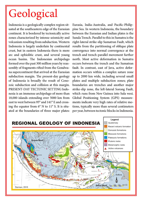
Geological Indonesia is a geologically complex region sit- Eurasia, India-Australia, and Pacific-Philip- uated at the southeastern edge of the Eurasian pine Sea. In western Indonesia, the boundary continent. It is bordered by tectonically active between the Eurasian and Indian plates is the zones characterized by intense seismicity and Sunda Trench. Parallel to this in Sumatra is the volcanism resulting from subduction. Western right-lateral strike-slip Sumatran Fault, which Indonesia is largely underlain by continental results from the partitioning of oblique plate crust, but in eastern Indonesia there is more convergence into normal convergence at the arc and ophiolitic crust, and several young trench and trench-parallel movement further ocean basins. The Indonesian archipelago north. Most active deformation in Sumatra formed over the past 300 million years by reas- occurs between the trench and the Sumatran sembly of fragments rifted from the Gondwa- fault. In contrast, east of Java, active defor- na supercontinent that arrived at the Eurasian mation occurs within a complex suture zone subduction margin. The present-day geology up to 2000 km wide, including several small of Indonesia is broadly the result of Ceno- plates and multiple subduction zones; plate zoic subduction and collision at this margin. boundaries are trenches and another major PRESENT-DAY TECTONIC SETTING Indo- strike-slip zone, the left-lateral Sorong Fault, nesia is an immense archipelago of more than which runs from New Guinea into Sula wesi. 18,000 islands extending over 5000 km from Global Positioning System (GPS) measure- east to west between 95° and 141° E and cross- ments indicate very high rates of relative mo- ing the equator from 6° N to 11° S. It is situ- tions, typically more than several centimeters ated at the boundaries of three major plates: per year, between tectonic blocks in Indonesia.
 Visual Guide Indonesia Page 3 Page 5